


Musi Riverfront | In the past..
In the presentation given to the public associations, the government stated that they will collect land on both sides of the Musi at the rate of one kilometer and make it a ‘development corridor’. When there was opposition to this, it was called ‘Tuch’. She said that we will be limited to the buffer zone.
The state government gave a PowerPoint presentation at a star hotel on the development of Musi. Musi Riverfront Development Corporation Limited (MRDCL) MD Narsimha Reddy announced that the buffer zone is only 50 meters on both sides of the river.
Recently..
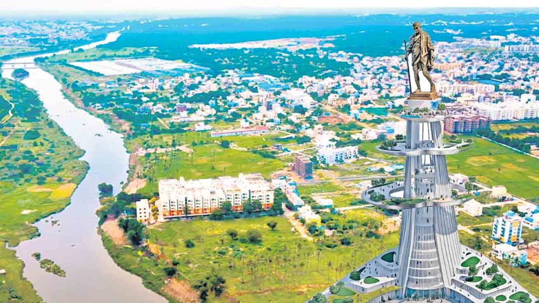
The government has released the first land acquisition notification as part of the ‘Gandhi Sarovar Project’. In this, notices have also been issued for structures far away from the buffer zone.
MRDCL has issued a tender notification for 3D digital modeling of structures located at a distance of a kilometer on both sides of Musi. The government has decided to do 3D digital modeling in an area of 42 square kilometers on both sides of the 21 km long river.
Which of these is true?
It is a stark truth that the government is deceiving people in the name of Musi project. It is a stark fact that lakhs of houses will be demolished, lakhs of people will be made homeless and the pockets of elders will be filled. Although the government and officials are saying that the buffer zone is only 50 meters on both sides of the river, they are going to demolish the structures for a kilometer on both sides. This is evident from the analysis of past and recent evidence.
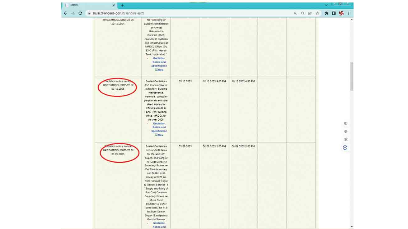
Not on the e-procurement website but only on the MRDCL website.
Tender Notifications

3D Digital Modeling Tender Notification by Musi Riverfront Development Corporation Limited
Hyderabad City Bureau Chief Spokesperson, March 19 (Namaste Telangana): ‘How many are the Pancha Pandavas? They say three are like chickens in a bed and point two fingers’. The Revanth Reddy government has been repeating the same saying for two and a half years on the account of the constructions of the common people included in the beautification of Musi. How much land acquisition is done on both sides of the river? How many structures will be removed? How many people will be homeless? The government has not clarified the details. In government presentations, official forums and in the legislative assembly, there is no clear statement on what basis Musi will acquire land for beautification.
In the presentation given to the public in the past, the government has made it clear that land will be collected at the rate of one kilometer on both sides of Musi and it will be made into a development corridor. As there was strong opposition to this, it said ‘Tuch..’. It has been announced that it will be limited to the buffer zone. Recently, in a PowerPoint presentation given by the state government at a star hotel, MRDCL MD Narsimha Reddy limited the technical details to a 50 meter buffer zone. But the details of how many structures will be affected are not mentioned anywhere. But, in the first land acquisition notification issued for the ‘Gandhi Sarovar Project’ in the first phase, notices were also issued for structures far from the buffer zone. With this, it is clear that land will be collected for kilometers on both sides of the river.
Recently, another evidence has emerged. Moosi Riverfront Development Corporation Limited (MRDCL) has issued a tender notification for 3D digital modeling of structures located at a distance of a kilometer on both sides of Moosi. With this, it has been proved that as ‘Namaste Telangana’ has been saying for the last one year, they are going to take forward the Musi beautification project by choosing the area as a corridor at the rate of one kilometer on both sides. That means the government will acquire 110 square kilometers of land with a length of 55 kilometers. There are more than one lakh structures in that area, which can be understood by simply checking Google.
Joint tender notification
The official documents of the Musi beautification project have been kept very secret by the government since the beginning. Estimated cost of the project, Comprehensive Project Report (DPR), How much land will be acquired as part of the project? How many houses will be removed? The details are being kept under wraps. One thing is given in the gazette, another is said on the stage, and lakhs of houses are going to be flooded with mushy water instead of making noise. Officials who are in a responsible position and should be transparent about the project are also maintaining secrecy in disclosing the details. As the CM, Ministers, MRDCL officials and revenue officials are disclosing the details of the project in a way that no one can match, the people of Musi catchment area are getting worried.
Less than two days ago, BRS Working President KTR also said that the government has no plan regarding the Moosy project and the details disclosed are not complete. At such a time, one of the tender notifications kept confidential by MRDCL officials has gone viral on social media. A notification has been released to select agencies for 3D digital twin modeling of structures within a kilometer on both sides of Musi. The tender notification (05/EE/MRDCL/2025-26) was issued with an estimated value of Rs.18 lakhs.
As the first phase (Gandhi Sarovar) of the beautification project to be undertaken by the government in 5 phases is being carried out along 21 kilometers (Himayatsagar-Bapughat, Gandipeta-Bapughat), it has been decided to do 3D digital modeling in an area of 42 square kilometers on both sides of the river. In fact, even though these tenders were called confidentially at the end of 2025, there was no response from the bidders. With this, a second (recall) notification was issued on the sixth of last month. What is the current status of this tender? Have you chosen an agency? Have you started the 3D digital modeling process? Officials are keeping the information confidential.
Usually the tender notifications given by the government departments and departments are kept only on the MRDCL website instead of on the e-procurement website from time to time. The latest 3D digital modeling tender notification is finally not available on the MRDCL website. But this tender notification number (04) before (05) and after (06) notifications are visible on the website. This means that the authorities have deliberately kept the notification secret.
In the report given by MRDCL to the World Bank, it has been said that a corridor will be developed for tourism, finance, trade, commerce, entertainment and real investments in the Musi basin. That means ventures for the real estate sector, hotels, restaurants, entertainment centers, office space, etc. will be undertaken in a Seoul-style development model. To this extent, public representatives and media were also taken on a trip to Seoul. All these are not possible in a 50 meter buffer zone, according to experts. It is clear that land will be collected beyond the buffer zone.
MRDCL officials have recently issued a notification for 3D digital modeling of the kilometer range. If the buffer zone is 50 meters then why 3D digital modeling in kilometer range is the real question. It is clear that the project will be extended to a kilometer on both sides of the river.
Why 50 meters and kilometer range?
Neither the government nor the MRDCL has yet revealed where and how wide the river bed, FRL and buffer zone have been determined in the Musi beautification project. Already up to 300 poor houses have been demolished in Chadarghat area. When asked, she said the houses in the river. Now the first phase up to Bapooghat has extended the buffer zone to 50 meters on both sides of the river. Madhu Ridge Park, Himayatsagar, Hanumannagar and other 15 colonies along with vacant lands have been included in the land acquisition notification given a few days ago. It is said that the land and structures will be collected only up to the buffer zone of 50 meters, but at the field level, the local people are complaining that the boundaries are 700 meters to a kilometer old.
If only 50 meters is true, the question is why digital modeling of structures and lands within a kilometer on both sides of the river is being done. Many measures taken by the government in the past also add strength to the argument that they will take over the lands within a kilometer on both sides of the river. Minister Sridhar Babu, TPCC President Mahesh Kumar Goud along with MRDCL officials arranged a special meeting with the voluntary organizations last year. Musi gave a PowerPoint presentation on the project. In it, it is stated that a kilometer range on both sides of the river will be identified as a corridor and developed.
In the report given by MRDCL to the World Bank, it has been said that a corridor will be developed for tourism, finance, trade, commerce, entertainment and real investments in the Musi basin. That means ventures for the real estate sector, hotels, restaurants, entertainment centers, office space, etc. will be undertaken in a Seoul-style development model. To this extent, public representatives and media were also taken on a trip to Seoul. These are not possible within the 50 meter buffer zone. Recently, MRDCL officials have released a notification for 3D digital modeling of the kilometer range. It is clear that the project will be extended to a kilometer on both sides of the river.
Minister Sridhar Babu, TPCC President Mahesh Kumar Goud along with MRDCL officials have arranged a special meeting with the NGOs. Musi gave a PowerPoint presentation on the project. In it, it is stated that a kilometer range on both sides of the river will be identified as a corridor and developed.
The compensation order is per kilometer kit
Ever since the Musi beautification project was brought to the fore, the theft being played by the Revanth Reddy government has been being explained to the public in the form of ‘Namaste Telangana’ stories from time to time. As a part of this, ‘Kilometer’ was scrapped a year ago. But the government is making statements and giving explanations to the officials that there is no such thing. ‘Namaste Telangana’ has analyzed the amendment orders (GVO-16) brought to GEO 168 on land acquisition compensation in January this year and revealed the government’s hidden agenda. The order states that TDR (Transferable Development Rights) will be given as compensation for water harvesting structures (such as ponds, rivers, canals).
If they are under Riverbed/FRL/FTL, the Sub-Registrar will give 200 percent compensation of book value (government rate) in the form of TDR bonds. Similarly, they said that they will give 300 percent in the buffer zone. In addition to this, if it is beyond the buffer zone, it has been clarified that 400 percent compensation will be given. That is, there were suspicions that the compensation beyond the buffer zone was also included because the government had an agenda to take constructions beyond the buffer zone. Now it is finalized with 3D modeling tenders.
The government has issued an order that transferable development rights will be given as compensation for water harvesting structures. Among them, it has been clarified that 200 percent of the sub-registrar’s value will be given if it is within the riverbed/FRL/FTL, 300 percent if it is in the buffer zone, and 400 percent if it is beyond the buffer zone. Does it mean that compensation has also been announced because there is an agenda to take structures beyond the buffer zone? Doubts are being expressed.